A mixed month, both marginally warmer and wetter than average - no prolonged warm or dry spell, the 15-18th being the best on offer.
August just never real got going. Whilst we had some good days, they were infrequent and often followed or preceded by something less good. The month started unsettled and was generally changeable during the first fortnight. There was a slight shift to more settled weather in the second half, although the 20th had a notably vigorous depression for the time of year which brought a period of wet and windy conditions.
MSLP of 1016.6 Mb was +2.5 Mb above the local average for August, which with the two unseasonal depressions during the month, being slightly wetter than average and the generally mixed theme is slightly surprising.
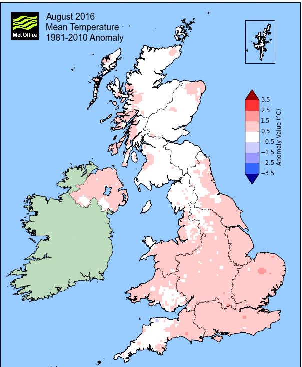
Overall a mean minimum of 10.88°c and a mean maximum of 18.91°c saw the temperature 0.3°c above the 1981-2010 average and it was the warmest August since 2013 (the 2nd warmest of the 8 now recorded at this site). The highest maximum temperature recorded was 23.9°c (16th), the lowest minimum 6.3°c (9th).
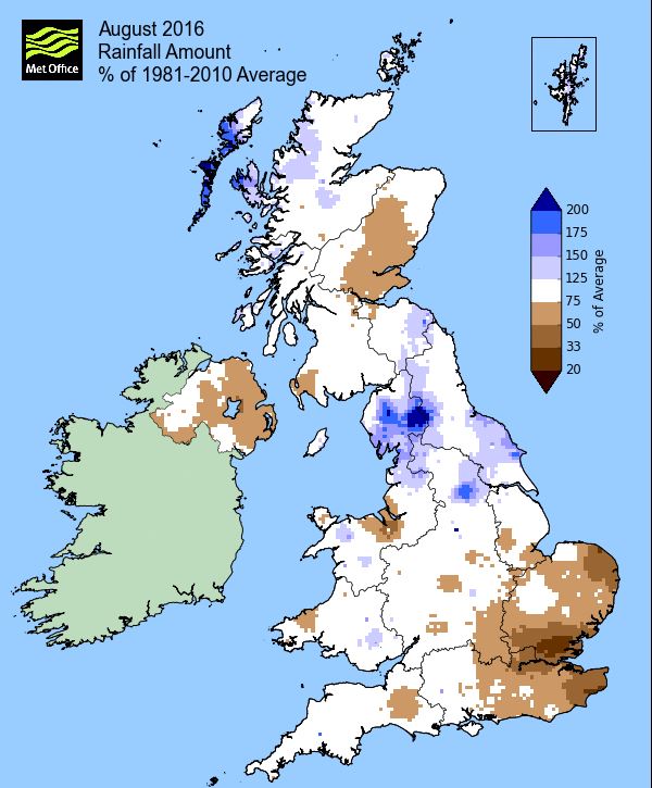
Rainfall of 133.0 mm (Crosby Ravensworth School 141.5 mm - CastleHowe Scar 150.1 mm and at Reagill, 147.1 mm) made it the wettest August since 2014 (the 4th wettest of the 10 now recorded at this site) and was 119.8% of average for 2007-15. Locally, rainfall percentages were well above normal, more so in the east of the county and through the Lake District, Seathwaite having as much as 162% of average rainfall. However, those percentages fell to just below normal further west and north in the county.
At the Met' Office site at Newton Rigg, 97.2 mm (138.7%) made it the driest August since 2013 and in a series back to 1900 there have been 38 wetter and 77 drier (with incomplete data for 1 year). In a series back to 1951, a mean temperature of 14.65°c is the warmest since 2013 with 18 having been warmer, 4 having the same temperature and 43 colder in that time.
Figures from the Environment Agency’s rainfall sites were, (figure in brackets being the monthly average for 1961-90) ‘Data kindly provided by the Hydrometry and Telemetry team of the Environment Agency (Penrith)’:
Kirkby Thore 58.4 (68.5 mm) - but missing data for 1st to 11th
Brothers Water 275.7 mm (198 mm)
Nunwick Hall ??? (78.4 mm) - data not available - and
388.8 mm at Seathwaite Farm (Borrowdale - 240 mm [average for 1981-2010])
SUMMER
Here at Maulds Meaburn, summer 2016 with 293.5 mm of rain (Crosby Ravensworth 299.4 mm) has been the wettest since 2012 and is the 5th wettest of the ten now recorded. That 293.5 mm represented 99.8% of the rainfall for those previous nine summers and curiously made no change to the overall mean summer rainfall!
A mean temperature of 14.54°c is the warmest since 2013 and the second warmest of the eight summers now recorded. That 14.54°c makes the summer of 2016 some 0.55°c warmer than the average of those previous seven.
At Newton Rigg rainfall totalled 277.8 mm and had a mean temperature of 14.6°c. In comparison to the 1981-2010 averages this represented 139.7% of summer rainfall and it was 0.4°c warmer than average.
In a series back to 1900 (3 years of incomplete data), this was the 20th wettest and in a complete series back to 1957, 10 have been warmer, 46 have been colder, with 3 having the same mean temperature.
August
1st - 3rd Whilst the month opened with high pressure (HP) over France ridging north and giving a decent day of sunny intervals, low pressure (LP) west of Eire slowly pushed frontal systems south to north over the UK during the next two days.
Those frontal systems were slow moving with the 2nd-3rd being characterised by spells of rain, drizzle and frequent showers with the heaviest rain falling in the afternoon and evening of the 3rd, 13.0 mm and a subsequent dip in day-time temperatures.
4th - 6th The LP of the previous days very slowly cleared NE during the 4th, giving a nominal NW'ly flow and a cloudy day. The pressure slackened behind the LP with HP moving into Biscay and extending north over the UK by the 6th.
This brought another two reasonable days for the 5-6th although any sunshine was somewhat hazy.
7th - 9th An unseasonably deep depression tracked north east out of the Atlantic towards Faroe and whilst the rainfall was slight, the winds on its southern flank were strong. Both days saw gusts to 40 mph and whilst the 8th actually saw some decent sunny spells, the LP had tracked further NE and with HP building in the mid Atlantic a very fresh NW'ly was introduced. This saw the temperature drop by both day and night, with the 9th starting at 6.3°c (the month's lowest temperature) and only rising to 16.0°c.
10th - 13th
It then became a little mixed as the HP remained to our SW, but with LP SW of Iceland pushing fronts east. Late evening on the 10th and overnight into the 11th saw rain (15.1 mm) arrive on a frontal system associated to that LP, the day also being quite cool at just 15.5°c, the month's lowest maximum. Those fronts were quickly followed by the HP, now in Biscay, nudging north and generally quietening the weather to being generally cloudy with the odd spot of rain.
14th - 18th A spell of summer weather then arrived as HP in Biscay tracked slowly north through the Eire Sea, across the UK, exiting out into the North Sea. The airflow introduced may not have been a southerly, but the SSE'ly still came from off the continent and the days were probably more pleasant and bearable as a result.
The sun may not have been quite wall to wall on every day, the 16-17th been the better of the days, as variable amounts of cloud tended to make some of the days a little hazy. However, the 15-18th all comfortably attained 70°f with 23.9°c (75°f) on the 16th the month's highest temperature and the days were also dry.
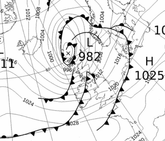
19th - 22nd A second unseasonably LP system then brought a wet weekend with the afternoon and evening of the 20th especially wet. LP (976 MB) that had been sat out in the mid Atlantic for some time finally deepened and approached the UK from the SW, moving NE.
An occluded front ahead the main centre of the LP brought 13.5 mm on the 19th, rain falling moderately from late morning into the afternoon. The main area of LP with its occluded front wrapped around the centre arrived on the 20th, with rain from 0930 hrs, becoming heavy at times in the afternoon and then again late evening after a brief lull. In total 34.0 mm (81.0 mm at Seathwaite Farm) easily made it the wettest day of the month and the wettest day since 26th January. But with winds gusting to 48 mph and a maximum temperature of just 15.6°c the day was also quite cool.
The LP steadily drifted away NE, but fronts on its southern flank brought more rain overnight into the 21st. The 21st saw a cloudy and breezy day ahead of yet more rain brought by a new LP system from of the Atlantic. However, rain of 14.8 mm didn't arrive until the late evening, continuing overnight into the 22nd.
After that rain on the 22nd the day slowly improved to sunny spells in the afternoon and the temperature responded and reached a high of 21.8°.
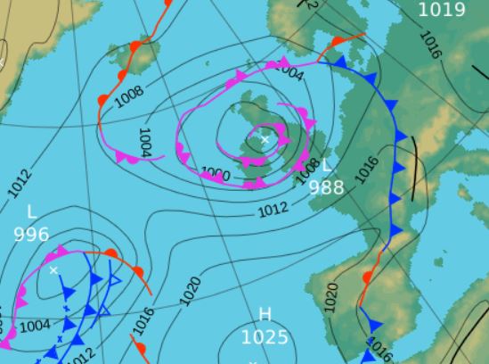 Mid-day 20th - the second unseasonably low pressure that brought a wet weekend
23rd - 31st The rest of the month was generally a mixed bag of good days interspersed with less good ones and the one main fall of rain during the period fell overnight.
Firstly, the 23rd-24th saw two lovely sunny and warm days as the pressure gradient slackened and we remained clear of any fronts, albeit they were still fairly close by and brought some rain overnight into the 23rd. The 23rd after an overcast start saw the sun soon burn the cloud away with the best of the sun in the afternoon and evening with a high temperature of 23.4°c.
Whilst not quite so warm, the 24th was probably the better day with wall to wall sunshine as a weak ridge of HP tried to nose in. The 25th saw a little rain both early morning and late evening and was generally cloudy inbetween
The cold front that had moved through late 25th saw cooler and clearer air following the front and which allowed HP to build from the SW. Subsequently the 26-27th had decent sunny spells with the 27th again rising above the 20° mark.
Yet another LP system from the SW with an occlusion wrapped around the centre then arrived overnight into the 28th, giving 18.5 mm of rain by morning. Once again the HP would ridge back 29th and the day was a lovely one with plenty of sun.
And it remained mixed at the very end of the month as we sat on the boundary of HP to our SE and LP in the Atlantic, the better of any brightness coming on the 31st.
Rainfall totalled 133.0 mm for the month, with rain recorded on 19 days of which 13 were 'Wet days' (1.0mm +).
The Mean Temperature for the month was 14.90°c -- The Mean Max' was 18.91°c -- The Mean Min' 10.88°c.
We had 0 Air Frosts in the month (year 39) -- Grass frosts totalled 0 (year 83).
The 1 foot soil temp ranged from a low of 15.3°c on the 11th to a high of 17.2°c on the 25th -- with a monthly mean of 16.1°c
The 1 meter soil temp ranged from a low of 14.1°c on the 14th to a high of 14.8°c on the 27th -- with a monthly mean of 14.5°c
COMPARISONS:-
* August 2016 rainfall was 119.8% of the August average for 2007 - 2015
* August 2016 was 0.78°c warmer than the August average for 2009 - 2015 and 0.3°c warmer than the local long term average 1981-2010
* 2015 Jan - Aug TEMP 8.62°c -- RAIN 753.8 mm
* 2014 Jan - Aug TEMP 9.96°c -- RAIN 959.9 mm
* 2013 Jan - Aug TEMP' 8.55°c -- RAIN 634.9 mm
* 2012 Jan - Aug TEMP' 8.97°c -- RAIN 744.8 mm
* 2011 Jan - Aug TEMP' 9.20°c -- RAIN 777.6 mm
* 2010 Jan - Aug TEMP' 8.26°c -- RAIN 314.2 mm
* 2009 Jan - Aug TEMP' 9.44°c -- RAIN 760.3 mm
* 2008 Jan - Aug TEMP' -- RAIN 861.7 mm
This makes the Jan' to Aug' period of 2016 0.22°c warmer than the average for 2009-15 and with 108.6% of average rainfall for 2008-15
JANUARY 2010
FEBRUARY 2010
MARCH 2010
APRIL 2010
MAY 2010
JUNE 2010
JULY 2010
AUGUST 2010
SEPTEMBER 2010
OCTOBER 2010
NOVEMBER 2010
DECEMBER 2010
JANUARY 2011
FEBRUARY 2011
MARCH 2011
APRIL 2011
MAY 2011
JUNE 2011
JULY 2011
AUGUST 2011
SEPTEMBER 2011
OCTOBER 2011
NOVEMBER 2011
DECEMBER 2011
JANUARY 2012
FEBRUARY 2012
MARCH 2012
APRIL 2012
MAY 2012
JUNE 2012
JULY 2012
AUGUST 2012
SEPTEMBER 2012
OCTOBER 2012
NOVEMBER 2012
DECEMBER 2012
SUMMER 2012
REVIEW OF 2012
JANUARY 2013
FEBRUARY 2013
MARCH 2013
APRIL 2013
MAY 2013
JUNE 2013
JULY 2013
AUGUST 2013
SEPTEMBER 2013
OCTOBER 2013
NOVEMBER 2013
DECEMBER 2013
REVIEW OF 2013
JANUARY 2014
FEBRUARY 2014
MARCH 2014
APRIL 2014
MAY 2014
JUNE 2014
JULY 2014
AUGUST 2014
SEPTEMBER 2014
OCTOBER 2014
NOVEMBER 2014
DECEMBER 2014
WINTER 2014
REVIEW OF 2014
JANUARY 2015
FEBRUARY 2015
MARCH 2015
APRIL 2015
MAY 2015
JUNE 2015
JULY 2015
AUGUST 2015
SEPTEMBER 2015
OCTOBER 2015
NOVEMBER 2015
DECEMBER 2015
REVIEW OF 2015
JANUARY 2016
FEBRUARY 2016
MARCH 2016
APRIL 2016
MAY 2016
JUNE 2016
JULY 2016
© Darren Rogers 2016
Want to comment on this site? email